Most of India’s major rivers flow east, into the Bay of Bengal. The Tapi is one of only three large Peninsular rivers that run the other way, west into the Arabian Sea. It even does something the famous Narmada doesn’t do. The Narmada carves a dramatic canyon on its way to the sea. The Tapi instead ends quietly, spreading into a wide tidal estuary near Surat — one of the few true river estuaries anywhere in India.


 MCQ Questions
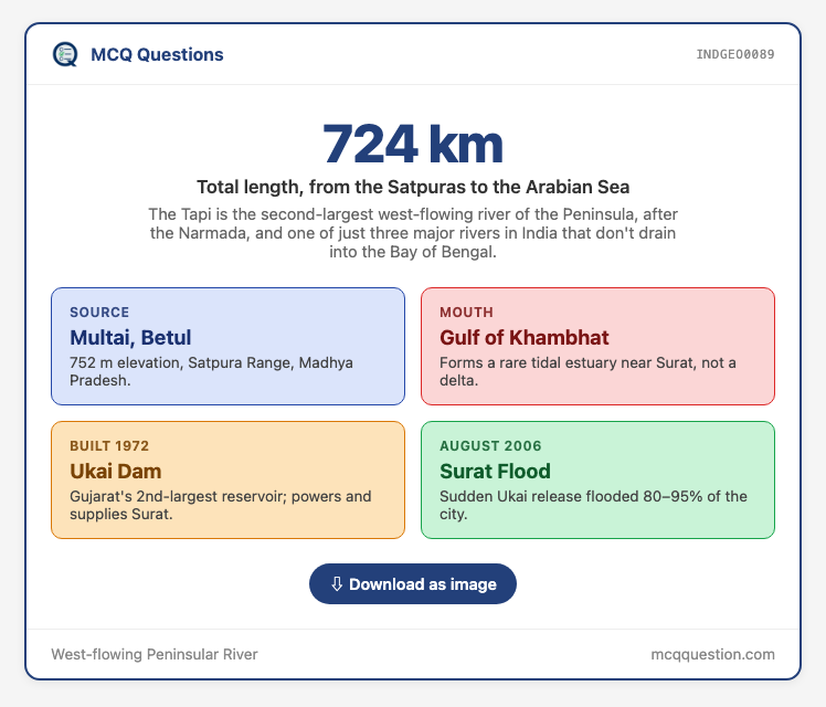
Most Indian rivers flow east. The Tapi is one of just three big ones that don’t — and instead of a delta, it ends in a rare tidal estuary at Surat.
1. A West-Flowing Exception
1.1 Why does the Tapi flow the “wrong” way?
The Tapi rises near Multai, in Betul district of Madhya Pradesh, at about 752 m elevation, in the Satpura Range.
- It flows for about 724 km, from central India to the Arabian Sea, with a basin covering roughly 65,145 sq km.
- The Tapi flows west, not east, a direction it shares with only the Narmada and the Mahi among major Peninsular rivers.
- Among these west-flowing rivers, the Tapi is second-largest by length and discharge, after the Narmada.
- Like the Narmada, the Tapi flows through a rift valley, guided by old faults rather than ordinary erosion.
- The Tapi’s rift valley runs roughly parallel to, and just south of, the Narmada’s own rift valley.
- The Satpura Range forms much of the Tapi valley’s northern wall, the same range that also bounds the Narmada.
True or False: The Tapi, the Narmada, and the Mahi are the only three major Peninsular rivers that flow west into the Arabian Sea.
Correct! Most other major Peninsular rivers flow east, into the Bay of Bengal.
Not quite. These three rivers are the exception among major Peninsular rivers.
2. Course and Tributaries
2.1 Which states and cities does the Tapi pass through?
The river passes through Madhya Pradesh, Maharashtra, and Gujarat before reaching the sea.
- It has 14 major tributaries, including the Purna, Girna, and Panjhra.
- The Tapi Valley is also known locally as Khandesh, a historic region spanning parts of Maharashtra and Madhya Pradesh.
- Khandesh has long been known for cotton cultivation, thanks to the fertile black soil along the Tapi’s banks.
- The Tapi ends in a tidal estuary near Surat, where it meets the Gulf of Khambhat, unlike most Indian rivers that end in a delta.
- Surat itself grew into a major Mughal-era trading port thanks to its position on the Tapi’s estuary.
- The British East India Company also established one of its earliest Indian trading posts at Surat.
- Modern Surat is also India’s leading centre for diamond cutting and polishing, built on the same riverside location.
- Surat is also a major textile and synthetic-fabric manufacturing hub, alongside its diamond industry.
- Surat is today one of India’s fastest-growing large cities, sitting right on the Tapi’s banks.
3. The Ukai Dam
3.1 What does the Ukai Dam do for Surat?
The Ukai Dam was built across the Tapi in 1972, and is Gujarat’s second-largest reservoir after the Sardar Sarovar Dam.
- Ukai generates about 300 MW of power, and also supplies drinking and industrial water to Surat.
- Ukai’s reservoir, also called Vallabh Sagar, is one of the largest earthen dams in India.
- Its canal network irrigates farmland across southern Gujarat, alongside its power and drinking-water roles.
- A new barrage on the Tapi, connecting Rundh and Bhatha, is planned to secure Surat’s water supply for the next 50 years.
4. The 2006 Surat Flood
4.1 What happened in August 2006?
In August 2006, heavy upstream rain forced the Ukai Dam to release nearly 9 lakh cusecs of water in a short span.
- The Tapi overflowed and flooded 80–95% of Surat city.
- The flood killed over 150 people and caused economic losses above ₹21,000 crore.
- Millions were left stranded for days without food or clean water.
- Officials had received warnings about the dam’s rising level, but releases came too late to prevent the surge.
5. The Estuary Ecosystem
5.1 What makes the Tapi’s estuary important?
The estuary near the river’s mouth supports mangroves and a rich mix of freshwater and marine life.
- Its strong tidal range makes it one of India’s most productive river-mouth ecosystems.
- Hazira port, near the Tapi’s mouth, handles millions of tonnes of cargo each year.
- The same high tidal range that helps the estuary’s ecology also complicates shipping and port planning there.
- Surat has started the Tapi Shuddhikaran (Tapi Revival) project, aiming to clean up and rejuvenate the river through the city.
- A separate riverfront project aims to redevelop the Tapi’s banks through Surat for public use.
Exam Practice: PYQ Pattern
Common traps in this topic:
- Questions test whether National Waterway numbers are correctly matched to their rivers.
- How to prepare: fix the anchor facts — 724 km, Multai/Betul, Gulf of Khambhat, 1972 Ukai Dam.
A National Waterways Trap. UPSC asked which National Waterway-river pairs were correct, among NW-1:Ganga, NW-10:Amba, and NW-100:Tapi.
Answer: (d) All three pairs are correctly matched. NW-1 runs on the Ganga, NW-10 on the Amba, and NW-100 on the Tapi.
Quick recall: What combination of features makes the Narmada and Tapi unusual among Peninsular rivers?
They flow west, through rift valleys, into the Arabian Sea.
6. Estuary, Not Delta
6.1 Why does the Tapi end so differently from most Indian rivers?
The Tapi’s estuary, not a delta, is the key to why it behaves so differently from east-flowing rivers like the Ganga or Godavari.
- East-flowing rivers slow down and drop sediment into a fan-shaped delta as they near the sea.
- The Tapi instead flows into a narrow, steep-sided rift valley all the way to the coast, where tides push seawater far upstream.
- The Narmada and Tapi are often paired in exam questions as India’s two great rift-valley rivers, but their endings differ sharply.
- The Narmada cuts a dramatic gorge at the Marble Rocks near Jabalpur; the Tapi’s drama comes right at its mouth, in the tidal estuary at Surat.
- The 2006 Surat flood shows how the same dam that gives a city its water and power can also be the reason it floods.
- Ukai’s reservoir was kept too full going into the 2006 monsoon, and dam operating rules for the Tapi basin were revised after the disaster.
7. Current Affairs
7.1 What happened at Ukai in 2026?
On 7 July 2026, heavy upstream rain pushed Ukai Dam’s water level to 311.67 feet, a record-breaking rise. (Source: Sandesh)
- Surat’s weir-cum-causeway, at Singanpore, overflowed as its level reached 6.70 metres, above its danger mark.
- Authorities closed the causeway to traffic and put the city on high alert, echoing the risks that caused the 2006 flood.
MCQ on The Tapi River
Try 6 practice questions on The Tapi River.
Question 1 of 1
Question 1 of 1
Question 1 of 1
Question 1 of 1
Question 1 of 1
Question 1 of 1
Leave a Reply