Imagine turning a slice of the Thar Desert into farmland, just by routing river water 837 km across it. That’s exactly what the Indira Gandhi Canal does — India’s longest canal, and the reason a once rain-dependent desert now grows wheat, cotton, and kinnow oranges. Let’s trace how it got built, and what it actually cost to build it.


💧 Indira Gandhi Canal, at a glance
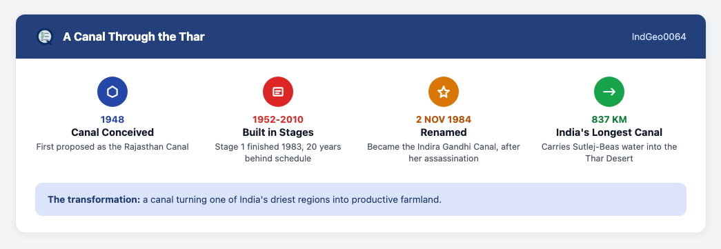
India’s longest canal, carrying Sutlej-Beas water 837 km into the Thar Desert
Where it starts
Harike Barrage, Punjab — the Sutlej-Beas confluence.
Where it ends
Near Gadra Road, in the Thar Desert, western Rajasthan.
Its length
837 km — India’s longest canal by a wide margin.
Renamed in
1984, after Indira Gandhi’s assassination that year.
On this page
Course and Basic Facts
From a Punjab Barrage to a Desert District
The Indira Gandhi Canal begins at the Harike Barrage in Punjab — the exact point where the Sutlej and Beas rivers meet. From there it flows through a short stretch of Haryana, before finally ending in the Thar Desert near Gadra Road, in western Rajasthan.
At 837 km, it’s genuinely India’s longest canal, by a wide margin. And it’s not a small side-project either. Its command area covers roughly 19,000 square kilometres. That area spans districts including Ganganagar, Hanumangarh, Bikaner, and Jaisalmer. In total, nine districts across western and northern Rajasthan draw real benefit from its irrigation and drinking-water supply.
- What it actually changed: it transformed agriculture across western Rajasthan’s desert soils, bringing irrigation to a region that had depended almost entirely on rainfall.
The Four Sections
Built in Pieces, Not All at Once
The canal isn’t one uniform stretch — it’s four named sections, built and extended over decades. The Rajasthan Feeder Canal runs 204 km, from Harike Barrage to Masitawali village. The Indira Gandhi Main Canal is the longest single section at 445 km, running from Masitawali to Mohangarh. Two smaller sections, the Sagarmal Gopa Branch Canal and the Baba Ramdev Sub-branch Canal, complete the system.
The 1984 renaming, after Indira Gandhi’s assassination that year, wasn’t unique to this canal. Several major Indian infrastructure projects were renamed after her the same way, around the same time.
- The engineer behind it: Kanwar Sain, an Indian irrigation engineer, is widely credited as the canal’s original chief planner. He later chaired India’s Central Water Commission.
- What it made possible: wheat, cotton, mustard, and groundnut are now major crops across the canal’s irrigated command area. Kinnow orchards have spread widely in some districts too.
True or False: All four sections of the Indira Gandhi Canal were constructed at the same time, as one continuous single-phase project.
What the Delays and Renaming Reveal
A 20-Year Delay, and What It Tells You
Here’s a fact worth sitting with: Stage 1 alone took 20 years longer than planned. That’s not a footnote — it’s actually a pattern worth recognising. Large-scale water infrastructure projects in India often run well past their original timelines, without the underlying project getting derailed entirely.
The canal’s four-section structure tells the same story from a different angle. It was built and extended incrementally over decades, not as one continuous single-phase project — each section reflects its own distinct construction era.
And the water itself carries a real trade-off. Diverting river water hundreds of kilometres into a desert region raises genuine long-term questions about upstream availability, not just the immediate benefit downstream. Every litre routed to the Thar Desert is a litre no longer available upstream — a real trade-off, not a cost-free act of engineering generosity.
- The bigger picture: the Thar Desert’s shift toward irrigated agriculture shows how one infrastructure project can reshape a region’s entire economy, not just its water supply. Entirely new agricultural towns and market centres have grown up along the canal’s route, in areas that were once sparsely populated open desert. Population in several of these newly irrigated districts has grown substantially since the canal opened.
What Does Keeping a Desert Canal Running Actually Cost?
Seepage, Salinity, and the Maintenance That Never Stops
Building a canal through a desert doesn’t end the story — keeping it working does. Here’s the chain of problems, in the order one causes the next:
- Seepage. Unlined stretches of the canal historically lost significant water straight into the desert sand.
- Waterlogging. That lost water raised local groundwater tables enough to cause waterlogging in some areas.
- Salinity. Waterlogging pulls naturally occurring salts upward through the soil, and left unchecked, that can genuinely make previously productive farmland unusable.
- Ongoing relining. Concrete lining has reduced the seepage loss, but it’s not a one-time fix — desert sand and shifting soil keep wearing linings down, so the work repeats periodically, usually scheduled as multi-week closures during lower irrigation demand.
Why This Canal Is a Textbook Planning Case Study
Two Planning Ideas, Tested at Once
Two exam-relevant planning concepts show up clearly in this canal, each testing a different question:
- Target area planning — focusing effort and resources on one specific problem region, instead of planning for the whole country at once. This canal’s command area, the desert districts it irrigates, is a classic example.
- Command area development — the follow-up work. A canal creates irrigation potential the moment it’s built, but that potential only helps farmers once land levelling, field channels, and drainage actually reach every plot.
- Sustainable development — the harder question underneath both: can this development keep working decades later, without wrecking a later generation’s ability to meet its own needs? The canal’s own waterlogging and salinity problems are exactly the trade-off this idea is meant to catch early.
Target area planning decides where and how intensely to develop a region. Sustainable development asks whether that development holds up over time. This canal has spent decades testing both questions at once.
A Shared, Contested Resource
Remember this: at 837 km, the Indira Gandhi Canal is India’s longest canal. It carries Sutlej-Beas water from the Harike Barrage in Punjab into the Thar Desert. It was renamed after Indira Gandhi in 1984, the same year as her assassination.
Think it through, before reading on. The canal turned desert farmland productive — a clear win. So why do conservationists still worry about it?
Show the explanation
Irrigation doesn’t just help crops — it changes an entire desert ecosystem. New water sources have drawn in bird and wildlife species that rarely visited the Thar Desert before. That sounds like a gain. But the Great Indian Bustard, a critically endangered bird, needs exactly the opposite: open, undisturbed arid grassland with minimal human and agricultural activity. As farmland and settlements spread along the canal’s route, that grassland habitat shrinks. The same water that built new towns and markets is also squeezing the space a native, endangered species needs to survive. That’s the trade-off underneath “target area planning” and “sustainable development” as exam concepts. A region’s development and its ecological health don’t automatically move together. This canal is a real, ongoing example of that tension.
Current Affairs
A New Desert Lake (2026)
A 28-kilometre-perimeter artificial lake has taken shape at the Burji 1356 escape structure of the Indira Gandhi Canal, in Jaisalmer district. It was completed in July 2026. (Source: Yes Punjab, July 24, 2026) Under the Jal Jeevan Mission, it captures surplus monsoon water that previously flowed away toward the international border, unused, for lack of storage. The reservoir has an average depth of 13 metres and a storage capacity of 1,406 MCFT. It’s lined with HDPE sheets to prevent seepage into the sandy desert terrain. It’s a direct extension of the canal’s own escape-structure system, now repurposed to store water instead of losing it.
Quick Q&A
Q: Where does the Indira Gandhi Canal start and end?
A: It starts at the Harike Barrage in Punjab and ends near Gadra Road in the Thar Desert, Rajasthan.
Q: How long is it, and what’s its distinction?
A: 837 km — India’s longest canal by a wide margin.
Q: Why was it renamed in 1984?
A: After Indira Gandhi’s assassination that year, as part of a broader pattern of renaming major infrastructure after her.
Q: What’s the main ecological concern linked to the canal?
A: Irrigation-driven habitat change may threaten the critically endangered Great Indian Bustard, which needs undisturbed arid grassland.
✅ Test Yourself
Question 1 of 1
Leave a Reply